Showing posts with label indian ocean. Show all posts

Thursday, September 13, 2018

Safeguard Arabian Sea-Indian Ocean-Bay of Bengal from Chinese Encirclement of India


Hon’ble Chief Minister of Kerala                                                      19.10.2011 

Thiru.Ooman Chandi Tiruvananthapuram

Respected Chief Minister

Subject: Need to safeguard Arabian Sea-Indian Ocean-Bay of Bengal from Chinese encirclement of India, expansionism to indulge in sea floor mining and plans to dominate sea lanes connecting Saudi to China through oil pipelines beneath our seas and to awaken vigilance towards India’s security and national interests through Government of Kerala… regarding. Let me alert the Government of Kerala about the volcanic chains in Arabian Sea and Bay of Bengal where mining for oil, natural gas and minerals by Indian corporate and Chinese counterparts is on the anvil.


Let me bring to your notice that The International Seabed Authority in collaboration with the Government of Fiji and the Secretariat of the Pacific Community (SPC) SOPAC Division is organizing an International Workshop on Environmental Management Needs for Exploration and Exploitation of Deep Sea Minerals, to be held in Nadi, Fiji Islands from 29 November to 2 December 2011. 

● Let coastal states of South India like Tamilnadu, Kerala hereafter pay more attention to such workshops and debate the impact of deep sea mining off shore of respective states. Our appeal is to all Chief Ministers of Coastal states not to leave these workshops or activities of leasing out of our adjacent seas by International Seabed Authority as the domain of Indian foreign service bureaucrats of Union Government ministries. The after effects of deep sea mining will be borne by the people of coastal states and as their chosen representatives these Chief Ministers and politicians of these coastal states have to keep vigil on International Seabed Authority and countries like China which have dreams to become world power cutting down India to size in order to gain supremacy over India.

 This workshop takes place in the aftermath of The International Seabed Authority approving the application from the China Ocean Mineral Resources Research and Development Association (COMRA) to explore an area of the ridge for 15 years, covering about 10,000 square kilometers, on July 22 of 2011. China’s approval for conducting exploration activities in the Southwest Indian Ridge is the country’s second such area with exclusive rights, following the 75,000 square kilometer poly metallic nodule ore deposit in the east Pacific Ocean, which was licensed in 2001.

India, however, has become highly alarmed by this development, fearing that Beijing may use the exploration permit granted by the ISA as an excuse to operate their warships in the Indian Ocean – an area seen in India as clearly within its sphere of influence. Reports in India say that the country’s Directorate of Naval Intelligence has given a warning note to related defense departments. In the mid 1950s the oceans came under the freedom-of-the-sea doctrine – a 17th century principle that limited national rights and jurisdiction over the oceans to a narrow belt of sea surrounding a nation’s coastline.

The United Nations convened three conferences on the Law of the Sea producing four conventions dealing respectively with the territorial sea and the contiguous zone, the high seas, fishing and conservation of living resources in the high seas and the continental shelf. In 1970 after years of intensive efforts, the UN Assembly unanimously declared the seabed and ocean floor beyond the limits of national jurisdiction to be the common heritage of mankind and convened a conference in 1973 which would lead to establishing the International Seabed Authority to organize and control all activities in the Area with a view to administering resources.


It is from this Authority China had won approval to mine in Indian Ocean. The current areas of Chinese exploration are within the Clarion-Clipperton Zone (CCZ) in the Equatorial North Pacific Ocean and the Central Indian Basin in the Indian Ocean. Here it is pertinent to point to the Government of Kerala that China plans to bring oil through pipelines beneath Arabian Sea and Indian Ocean encircling India and to reach Hampanthotta harbor it has built in Southern Srilanka facing Indian Ocean. From there the current sea-lane where it brings oil through shipping vessels reaches South China Seas. China plans the oil pipeline to reach Yangoon in Myanmar. Then through vessels or pipelines in River Iravadhi it would reach the nearest point to China.

Proposed oil pipeline through Myanmar to reach China’s Yunnan province. China's largest oil firm and parent company of PetroChina will build and operate the pipeline whose construction is due to finish in 2013.The SinoMyanmar oil and gas pipeline starts at Kyaukryu port on the west coast of Myanmar and enters China at Yunnan's border city of Ruili. The 2,380-km long oil pipeline will end in Kunming City, capital of Yunnan. It is expected to carry 22 million tonnes of crude oil per annum to China from the Middle East and Africa. The natural gas pipeline will be even longer, running from Kunming into Guizhou Province and the Guangxi Zhuang Autonomous Region in south China for a total length of 2,806 km. It is expected to transport 12 billion cubic meters of gas to China every year. The project is the fourth way for oil and natural gas to enter China, after ocean shipping, the SinoKazakhstan pipelines and the Sino-Russian crude oil pipeline.
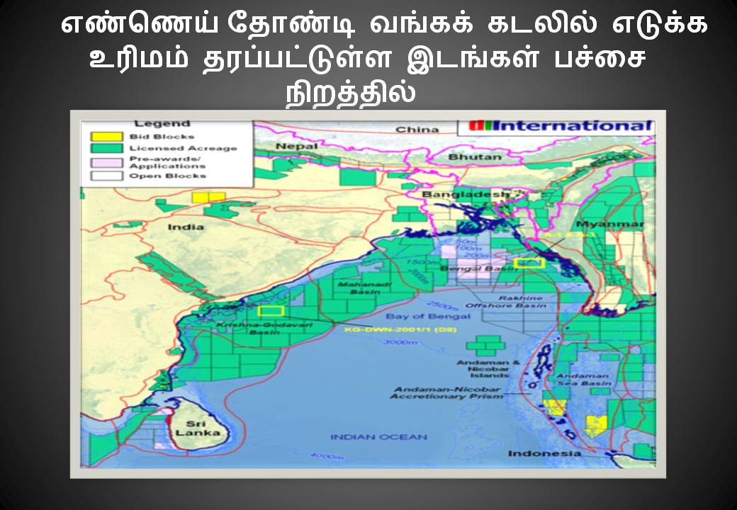

KERALA The geophysical field team of the ONGC found traces of oil in KeralaKonkan basin as early as 1977.ONGC employed the service of Geo-searcher, a Norwegian seismic-survey ship, to find evidence of oil in the KK basin, located 55-nautical miles (102 Km) off the Kochi shore. Later that year, another survey ship owned by a London based company conducted a comprehensive survey of the Kerala coast. 

The ship mapped sea floor from the Kochi coast to Ponnani. In 2008, Norsecot, commissioned by ONGC began experimental drilling off the Kochi coast. A floater type energy driller rig, capable of reaching 3500 meters into the sea was employed. In 2009, there were unconfirmed reports that the team had struck gold. The exploration was reported to have found traces of hydro carbons at a depth of 1500 meter. 

The war for the Continental shelves in 
Arabian Sea & Bay of Bengal 

There is oil in the Bay of Bengal and the evidence of Methane gas in the Shale treasures of the Arabian Sea point to rich deposits of Carbon based riches on the shorelines of Pakistan. Bangladesh, Myanmar and Pakistan are stuck in protracted stalemates on resolving the issues of the law of the sea. India’s claim over 300,000 sq. km of seabed in the Bay of Bengal that could potentially have large hydrocarbon reserves is being disputed by its eastern neighbours Myanmar and Bangladesh. 14 Myanmar,in 4 August 2009 letter to the United Nations (UN), has complained that India has unilaterally extended the maritime boundary between the two countries, contravening a 1986 bilateral agreement. A copy of the letter is available on the UN website. The maritime boundary between nations is an important reference point for establishing claims over untapped oil and gas, and mineral wealth in continental shelves. A continental shelf is the relatively shallow seabed surrounding a continent that could, in many instances, extend beyond a country’s exclusive economic zone, defined by the UN as a sea area within 200 nautical miles (360km) from the shore. 

The UN Convention on the Law of the Sea permits countries to claim continental shelf regions beyond the exclusive economic zone (giving exclusive fishing and mining rights), provided they can back it up with scientific data. On 12 May 2009, India staked claim to large swathes of seabed under the Arabian Sea and the Bay of Bengal, which a government scientist involved with the survey process pegged at approximately 0.6 million sq. km of continental shelf. The Bay of Bengal is not the only Continental Shelf that is being contested. The Arabian Sea is also being contested. Sir Creek makes a huge difference in the number of Nautical miles which come under the control of Pakistan or Bharat. Northwestern branch of the Indian Ocean, covering 3,859,000 sq km/1,489,970 sq mi, with India to the east, Pakistan and Iran to the north, and the Arabian Peninsula and Somalia to the west. It is linked with the Red Sea via the Gulf of Aden, and with the Gulf via the Gulf of Oman. Its depth is 2,730 m/8,956 ft. The chief river flowing into the Arabian Sea is the Indus, which is linked with a large submarine canyon in the continental shelf. The sea is rich in fish. Chinese released a guideline on the oceanic science and technology development between 2011 and 2015, vowing to invest more to boost the country's maritime economy. China is the fifth country to send a man 3,500 meters below sea level, following the United States, France, Russia and Japan. In our opinion, each country should think carefully of consequences ocean mining will have on the environment. Regarding who should share the profit, I think that both rich and poor countries should have the same rights. Those rights should be set by the International Law and everybody should respect that agreement. 


THAMIZHAN CANAL IN BAY OF BENGAL 3.11.2003


THAMIZHAN CANAL IN BAY OF BENGAL

In a letter to Prime Minister of India Atal Bihari Vajpayee and Prime Minister of Thailand Thaksin Shinawatra an appeal to construct 10 th Degree Canal was suggested. Then Dravida Peravai sent Memorandums to Indian Prime Minister Atal Bihari Vajpayee and Thailand Prime Minister Thakashin Shinawatra on 3.11.2003

August 15 th 2003, from Pondicherry Dravida Peravai wrote a letter to the Lt.Governor of Andaman and Nicobar Mr.N.N.Jha on the need to dig a canal in Thailand connecting Bay of Bengal and Gulf of Siam. It also urged that such Indo-Thailand joint venture be named as Thamizhan Calvaay. (Daily Thanthi 15.08.2003). Then Dinamani dated 28.08.2003 stated that a memorandum for construction of a " New Canal for benefiting Chennai and Tuticorin Harbor’s” had been handed over to the Union Minister of State for External Affairs Mr.Digvijay Singh. Mr.Singh lauded this project which will reduce 1500 nautical miles to reach South China Seas

 The details of the project are in this article.

Joint efforts by India and Thailand to construct the Tenth Degree Canal for linking Andaman Sea and Gulf of Thailand to create a short navigational route to South China Seas ensuring fuel savings and to act as catalyst for bilateral economic growth , is need of the hour.

You may be aware that the Suez Canal (1869) and Panama Canal (1915) Sethu Samudram Canal (1860) and Tenth Degree Canal have been mooted to create short navigational routes to bring prosperity to their respective regions and countries. The French initiative to build Siene_Norde Canal is an example for the keen interest evinced by developing countries to promote trade and overall development

Since the recent visit of Indian Prime Minister had given tremendous boost to the cooperation between India and Thailand, Dravida Peravai is bringing to your knowledge certain historical facts with the humble request to you both to take an active interest for the construction of Tenth Degree Canal, which can bring prosperity to Andaman & Nicobar islands of India and Thailand, apart from boosting bilateral trade.

You must go back to the pages of history to know that Thailand then known, as Siam is an enemy country of the British and an ally of the Japan during the World War II. On the conclusion of the Second World War II, one of the last secretive acts performed by the colonial Government of India was the signing of a Peace Treaty with Siam (Thailand). A Peace Treaty between her Majesty’s Government and the Government of India on one hand and the Kingdom of Siam on the other, on January 1, 1946 at the Government House Singapore. The signatories were for the Britain Mr. Moberly Dening, Political Adviser to Lord Louis Mount batten, for Government of India Mr.M.S.Aney and for Siam (now Thailand) Prince Viwat Anajai Jaiyant, Lt.General Phya Abhai Songgram and Nai Serm Vinichayakul. This treaty contains 24 articles. Out of this Article 7 assumes importance in the context of this letter.

Article 7: Siam undertakes to construct no canal linking the Indian Ocean and the Gulf of Siam (i.e. across the Kra Isthmus) without British consent. (Keesing’s Contemporary Archives 1946-48 Vol VI, p 7695). This article had done great havoc to Indian shipping costing our nation billions of extra money by way of fuel imports, in view of shelving of the Tenth Degree Canal project with the imposition of a condition in this Peace Treaty. It has also blocked the economic prosperity of Thailand and held up the development process by half a century and more.

Hence Dravida Peravai urges the Government of India and Government of Thailand to look into the unfavorable condition imposed by a colonial rule, that too at the threshold of a defeat in Second World War II on Thailand, an ally of Japan. It is in the interests of India and Thailand that a Canal be cut across the Isthmus of Kra where the isthmus narrows to just 75 miles and to develop this canal vigorously so that a detour of 1500 nautical miles down the Malayan Coast via the Straits of Malacca and up the Gulf of Thailand in the South China Sea is avoided.

The proposed Tenth Degree Canal will be an extension of the Tenth Degree channel in between Andaman and Nicobar islands. The opening of Tenth Degree canal will result is saving millions of tons of fuel foe world shipping. The Tenth Degree canal reduces the importance of other major canals of the world namely Suez Canal and Panama Canal. The Tenth Degree Canal would develop Andaman & Nicobar Islands and bring prosperity to its economy. The opening of this canal will also benefit the Indian East Coast Ports like Haldia, Paradeep, Visakapatinam, Chennai and Tuticurin.

There are more than 138 minor and intermediary ports under the control of various state governments in India. If Indian Government creates a National Seaway Authority and permits private sector vessels to transport cargo and passengers connecting all Indian Ports, these 138 minor and intermediary Ports, which mostly are inoperable, will be busting with activity and the opening up of the Tenth Degree Canal by Thailand will also improve its share in international trade and access to Indian market. The completion of Sethu samudram Project along with the Tenth Degree canal Project, will give a boost to Indian coastal shipping, cargo shipping and major boost to Indian and Thailand’s economy. The Tenth degree Canal will boost the economies of SAARC and ASEAN nations. 

The savings in fuel will be so great for Japan, and it may fund this project. India and China too would benefit with this Canal, and this will boost bilateral trade. The Tenth Degree Canal reduces the cost of shipping for the nations of the Pacific rim of Asia.

The Indian Prime Ministers vision to look towards East is laudable and the Free Trade Agreements India signing with its neighbours is a right step in the right direction, as world is moving towards regional blocks and common markets, Dravida Peravai urges both India and Thailand to foster their economic cooperation with speedy construction of Tenth Degree Canal as a Indo Thailand joint venture to open a New Seaway to East. Economists like Dominic Wilson and Roopa Purushothaman an alumnus of London School of Economics have in their joint report predicted that Brazil, Russia, India and China could become a powerful economic block like G-6 nations and will race ahead of developed nations by 2050. It will be appropriate to have a common Asian Market and A Common Asian currency for the resurgence of the economies of the Asian block, and by launching schemes with foresight both India and Thailand along with other neighbouring countries must set the agenda for changing their economies into one common market with a common currency.

The proposed land bridge between Thailand and Andaman is not necessary and instead the cutting of a canal right east from Andaman will be the easiest and best way to open a New Sea Way to South China Seas and EAST. India at the moment is planning a transshipment harbour in Indira point, the last island in our border, and this too could get a boost with the construction of Tenth Degree canal. There may be some voices of concern in environment angle, but such opposition will also be there for the land bridge mooted by the Thailand Government. Even for Sethu Samudram Project there was opposition and the National environment Research Institute had countered it in its report. For interlinking of rivers too there will voices against it here and there, but over all societal concerns must prevail. Nuclear tests are taking place amidst environmental caution, and in places where Tsunami, i.e. killer waves that rise from ocean floor and swallow towns is common as in Hawaii and Japanese regions harbours do exist and have come up. So it will not be an economically and environmentally unsound proposition to construct 10 Th Degree Canal and name it as THAMIZHAN CANAL.

Tuesday, September 11, 2018

ORPHANS UNDER OWN GOVERNMENT : TAMIL FISHERMEN


REGAIN KACHACHA THEEVU
TO SAVE OUR FISHER FOLK
The New Indian Express dated 17th November 2011 in its front page carried a report from Madurai the title of which was BAN FISHING IN PALK STRAITS: COAST GUARD. Indian Coast Guard recommended declaring India-Srilanka International Maritime boundary line a No Fishing Zone in an affidavit filed in Madurai branch of Madras High Court.

On October 14 of 2011, the court hearing a public interest litigation filed by Advocate Stalin seeking protection for Indian fishermen, had passed an interim order directing the Coast Guard to deploy sufficient coast vessels under the supervision of senior Indian navy officials. In response to that PIL Coast Guard came out with such a suggestion which even a nincompoop won’t suggest. Protests by Tamilnadu Chief Minister Ms.J.Jayalalitha led to the Central Government directing Coast Guard to withdraw that foolish affidavit.

The only solution to stop everyday massacre and harassment of our fishermen is to redraw the maritime boundary between India-Srilanka and the issue should go before International Tribunal of the Law of Seas.

In a long drawn process through four conventions covering high seas, territorial seas, continental shelf and living marine resources which began in 1958, United Nations Organization had strived to evolve consensus which ended in U.N.O mooting out International Law of Seas 1982. It was ratified by India in 1995.

As per article76 of the International Law of Seas 1982 " The coastal state shall establish the outer edge of the continental margin wherever the same extends beyond 200 nautical miles from the baselines from which the breadth of the territorial sea is measured. On the submarine ridges, the continental shelf's outer limit shall not exceed 350 nautical miles from the baselines from which the breadth of the sea is measured."

IN ACCORDANCE WITH THIS PROVISION INDIA SHOULD HAVE GAINED 7 to 9 LAKH SQUARE KILOMETERS. But in negotiating to extend this exclusive economic zone India got another chance to regain Kachcha Theevu but faltered and missed the chance.

 The so called rights of Indian fishermen were never honoured and the Government of India must place a white paper in Indian Parliament on the merciless shootings and killings of fishermen by Srilankan navy. This assumes importance in the wake of Director of Border Security Management under External Affairs Ministry filing another affidavit in January 2012 in same court stating NO FISHERMEN WAS ATTACKED by Srilankan navy and Government of India has no proof of such occurrences. Daily newspaper reports have been reporting such attacks almost regularly, and a Government of India official has the audacity to tell a brazen lie before Madurai branch of Madras High Court. It is because our Members of Parliament irrespective of political affiliations have failed to echo Tamilnadu’s voice in Parliament. Hence in past the poets of Puducherry even organized a street corner poet’s symposium to awaken our Members of Parliament from slumber.

The new boundaries as per International Law of Seas 1982 must be redrawn and India should take care to get back Kachcha theevu. Without wasting time Indian Government must take this issue to the International Tribunal of the Law of Seas under United Nations for re-demarcating our territorial waters.

N.Nandhivarman General Secretary Dravida Peravai


Sunday, September 9, 2018

RE-THINK ICHINA-MYANMAR-BANGLADESH-SRILANKA POLICY


INDIA URGED TO RE-THINK ITS CHINA-MYANMAR-BANGLADESH-SRILANKA POLICY

Mr.S.M.KRISHNA
HON’BLE UNION MINISTER FOR EXTERNAL AFFAIRS NEW DELHI
Respected Thiru.S.M.Krishna

Subject: Re-appraisal of India’s China, Bangladesh, Myanmar, Srilanka policy sought

We from Tamilnadu and Puducherry are happy in seeing you well versed in International law and with vast experience in feeling the pulse of the people placed in the External Affairs Ministry in a juncture when India is at cross roads. We are socialists and you know why our heart beats in joy in finding you in a position to offer course corrections to India’s foreign policy. The urgent agenda, which we feel that awaits your application of mind, is the Chinese moves in each and every issue in international arena. China had been for years scheming to become the sole Super Power of Asia. Nothing wrong in any nation to aspire higher status, but that status when it tends to downsize India, it is our duty to counter Chinese dragon.

The editorial of leading English daily of India, Times of India dated 29th May of 2009 about Aung San Kyi contains a paragraph which I would like to quote:“ We have just concluded a spectacular democratic exercise and are still showing it off to the world .But unfortunately when it comes to speaking up for the defenders of democracy in Myanmar our voice drops to a whisper. To put it bluntly India’s foreign policy with regards to Myanmar is caught in a trap. We chose to play footsie with the military regime in the hope of getting access to Myanmar’s natural resources and to secure our north-east from infiltration. We have achieved a degree of understanding on border infiltration but have been well eclipsed by China as far as exerting influence in Myanmar is concerned. We have meanwhile let down the people of Myanmar in their quest for democracy. If India is to make amends, this new Government must redraw India’s approach map to Myanmar. Given our aspiration towards a greater role, New Delhi under the foreign ministry would do well to recalibrate its approach towards our neighbors, especially towards ruthless dictators whom nobody in the world particularly likes”

Tamils thank Times of India. The newspaper instead of dictator or neighbor had used plural which indirectly indicates the tin-pot dictator of Srilanka. These comments open a Pandora’s Box. Indian foreign policy had let down its own citizens in past.We Indian citizens, who rediscover the past, are baffled at the statement tabled in Indian Parliament on July 23 1974 by then Indian External Affairs Minister Mr.Swaran Singh [Lok sabha debates cols 186-201] for Re-Agreement between India and Srilanka on boundary in historic waters between the two countries and related matters. India must be aware what its own representative sought before UN Sub-committee on the need to extend its maritime belt in view of thorium find in Indian territorial waters. When we had national interest to extend our maritime belt, only a nincompoop would opt for an agreement that will hand over Indian island of Katcha Tivu to Srilanka by way of this agreement.

The handing over of Coco island by the foreign policy experts of seventies to Myanmar had paved way for China obtaining its in lease from Myanmar and to build a harbour there apart from installing Russian made radars and satellites to spy on Indian Missile programme operated from Orissa, a state of India just facing Coco islands in the west of the Bay of Bengal. Sitting entrenched in Eastern side of Bay of Bengal that too just 40 nautical miles away from Indian Territory of Andaman Nicobar islands, China had established its access and control of Bay of Bengal. The intelligent foreign policy experts who had no broad vision had opened the gateway of Bay of Bengal to the Chinese dragon.

But the threats from China are not only in our border but everywhere. Unless India watches every move of China, we will fail in our patriotic duty to preserve our nation and its status among comity of nations.“India and China are now members of the Financial Stability Board, the apex institution to monitor global risks of financial crisis. Their voting shares in the International Monetary Fund will also be slightly increased through an accelerated quota reform process. However post-reform the USA will retain its defacto veto power with a 17 percent share and the US, EU and Japan will control 53 percent of IMF shares. Individually the shares of US, UK, France and Japan will still be larger than China’s share of fewer than 4 percent.” Hence China had planned a new offensive according to Professor of National Institute of Public Finance and Policy Mr.Sudipto Mundle.

“Zhou Xiaochuan, Governor of the Chinese Central Bank on the eve of G-20 summit suggested that dollar should be replaced with SDR’s as the new reserve currency. The huge dollar reserves held by Central Banks and other global investors would be severely eroded if the dollar were to suddenly depreciate. Yet these investors cannot easily diversify away from the dollar since this itself would trigger dollar depreciation. The Chinese are particularly concerned, an estimated 1 trillion dollars of their total reserves of around 2 trillion are held in dollar asset. The SDR exchange rate is a weighted average of exchange rates of the major convertible currencies. Accordingly under Zhou’s proposals, China and other countries could convert their reserves from dollars to SDR’s at current exchange rates without any erosion in their value. Implementing such a proposal would also mark the end of the dollar as reserve currency.” This is the game plan of China which has let the cat out of its bag.
If China launches SDR missiles to strike at the Dollar regime, India had to toe Chinese line, if Indo-China-Srilanka partnership to ethnic cleansing of Tamils is a forerunner to such cooperation.

USA realizing the Chinese designs had been urging India to sign End-use Monitoring Agreement, Communications Interoperability and Security Memorandum agreement, and Logistics Support Agreement. China causes grave concern for USA, hence USA urges India to sign these pacts. China had become emboldened to say to USA to concentrate on western Pacific and China will look after eastern Pacific. Pacific Command Chief Admiral Timothy J Keating had recently exposed this game.

Are we with USA or are we with China? Is USA a grave danger to the territorial integrity of India or is China, the aggressor who claims our Indian State of Arunachal Pradesh will be a threat with high magnitude?

China had encircled India with tie-ups starting from Myanmar to Srilanka, Maldives to Pakistan and Bangladesh. With harbours in all these countries carefully built from 1990, China had acquired a might India cannot challenge. If China could suggest to USA to divide Pacific Ocean as eastern zone and western zone between them, will it not say to India confine to your coast in Bay of Bengal and from Myanmar China will control half of Bay of Bengal.

Will not China with harbours in Pakistan and Maldives suffocate Indian presence in Arabic Ocean? Sitting in Srilanka’s southern tip China could block passage to Bay of Bengal and from Myanmar control Malacca Straits. India which supports Srilanka hoping it will shield its geo-political interests will cut a sorry figure in days ahead. Srilanka needed the support of India only to finish the Tamil demand for homeland. Helping Srilanka to crush Tamil freedom struggle China had succeeded in sowing distrust towards India in Tamil minds. Each and every step China plans is to establish it as Super power of Asia. It is the neo-colonial power which will colonize Myanmar and Srilanka. In Indian state of Bihar, the influx of Chinese women to marry Indians born in Buddha’s land is silently establishing a Chino-Indian population like early Anglo-Indians.

Our foreign policy must be debated in Indian Parliament. Few individuals should not decide the foreign policy of a continent like India with 100 crore population. Ours is Indian Union, though it became unitary due to the trauma of partition, it must be borne that Indian States have a right to shape India’s foreign policy. Consensus can emerge in our National Integration Council, debates in Parliament can offer constructive course corrections, and Cabinet should not be bypassed, few people should not be shouldered with crafting nation’s foreign policy, however super brains they may be. 

But seeing how China had outwitted us by encircling India, and within India opening a Red corridor from Nepal to Andhra Pradesh where Maoists rule the roost, it becomes evident that China wants India again to become a colony, this time a colony of China will only get conduct certificates from Communist parties and not from Indians with common sense.

Tuesday, October 13, 2015

RETHINK ON ATOMIC POWER PROJECTS


EXPORT URANIUM AS ORE:
RETHINK ATOMIC POWER PROJECTS IN QUAKE PRONE ZONES

The sudden quest to uranium mining though Government of India floated the Uranium Corporation of India on 4th October 1967, need not surprise us. The single minded chase for nuclear power by Manmohan Singh Government has resulted in activating uranium projects within India. Jharkand , the state that houses the headquarters of Uranium Corporation of India has uranium deposits in East and West Singhbum districts. The length of the ore deposit is 160 kilometers in a width of 1 to 10 kilometers.

In Meghalaya the KPM Uranium Project [ Kyelleng-Pyndengsohiong-Mawatahbah] had gathered momentum.

In Andhra Pradesh the Tummalapalle Uranium Project , for which all clearances have been given by Government of India will be one of the top 20 of world’s uranium reserves, according to the Atomic Minerals Directorate. This is situated in the Southern belt of Kadappa District, where Y.S.Raja Reddy, Y.S.Rajasekara Reddy, former Chief Minister of Andhra Pradesh and his son Y.S.R.Jaganmohan Reddy were and are mining magnates. Sixty thousand tons of uranium in a depth of 400 meters is found upto 160 kilometers length and P.B.Maithani Director of Atomic Minerals Directorate opines that this can fuel generation of 5000 M we of nuclear power  for 30 years.

Apart from this Kadappa District where all  global players in mining and atomic power plants will be competing to gain foothold, Gogi in Gulbarga District of Karnataka too has 4000 tons were companies will make a beeline. In Rajasthan too at Rohil in Sikar District 5000 to 10000 tons of uranium deposits have been found.  India has 19 operating Pressurised Heavy Water Reactors that use natural uranium as fuel. In a way these uranium deposits found may feed the raw material requirements of our 20 Atomic power plants, out of which Koodangulam Plant had triggered a nation wide debate on the need to go for atomic power plants.

In the aftermath of Japan’s Fukushima Atomic Power Plant disaster, world wide second thoughts on atomic power plants had made many countries to go for a rethink. Germany which should phase out nuclear power plants by 2035 had advanced the deadline to 2020. Lithunia, a tiny country which was dependent on Russia reactors to produce 70 percent of its power needs parted from Russian Federation and joined European Union two years ago. Immediately it took a bold and risky step to shut down its atomic power plants. It joined hands with Japanese power giant Hitachi and American power company General Electrical Company to develop alternative energy which will be available by 2020. India need not be adamant but should explore other options. At the moment India has 20 atomic power projects, some of which are in earth quake prone zones, as demarcated by Government of India.

By Government of India’s own classification of danger zones as depicted in the picture above atomic power plants are coming up. Let there a rethink before a disaster occurs.Just because we have uranium deposits, we need not go for Pressurized Heavy Water reactors. India can mine uranium and export uranium as raw material as it had been exporting iron ore for decades without processing the iron ore in India.


N.Nandhivarman, General Secretary Dravida Peravai


OIL WARS AHEAD IN OUR OCEANS

OIL IN  THE CONTINENTAL SHELF OF 

ARABIAN SEAS &BAY OF BENGAL 

Editorials Monday, September 21st, 2009

There is oil in the Bay of Bengal and the evidence of Methane gas in the Shale treasures of the Arabian Sea point to rich deposits of Carbon based riches on the shorelines of Pakistan.  Bangladesh, Myanmar and Pakistan are stuck in protracted stalemates on resolving the issues of the law of the sea.

Myanmar says India has extended the maritime boundary unilaterally; Bangladesh to contest claims too

New Delhi: India’s claim over 300,000 sq. km of seabed in the Bay of Bengal that could potentially have large hydrocarbon reserves is being disputed by its eastern neighbours Myanmar and Bangladesh.

Myanmar, in a 4 August letter to the United Nations (UN), has complained that India has unilaterally extended the maritime boundary between the two countries, contravening a 1986 bilateral agreement. A copy of the letter is available on the UN website.

The maritime boundary between nations is an important reference point for establishing claims over untapped oil and gas, and mineral wealth in continental shelves.

Bangladesh Prime Minister Sheikh Hasina on 18 June said that her government was also planning to contest India’s and Myanmar’s claims to the extended continental shelf. This was reported in the Daily Star, a local English newspaper.

A continental shelf is the relatively shallow seabed surrounding a continent that could, in many instances, extend beyond a country’s exclusive economic zone, defined by the UN as a sea area within 200 nautical miles (360km) from the shore.

The UN Convention on the Law of the Sea (Unclos) permits countries to claim continental shelf regions beyond the exclusive economic zone (giving exclusive fishing and mining rights), provided they can back it up with scientific data. On 12 May, India staked claim to large swathes of seabed under the Arabian Sea and the Bay of Bengal, which a government scientist involved with the survey process pegged at approximately 0.6 million sq. km of continental shelf. The scientist asked not to be identified.


Mint on 12 June reported that India’s claim was likely to also conflict with regions claimed by Sri Lanka as its own, quoting top government officials involved in the process.

India’s external affairs ministry is likely to enter into bilateral discussions with these countries and resolve the contentious issues, rather than wait for the UN to take a call, said an official at the ministry of earth sciences, which was involved in conducting surveys and technically establishing the extent of India’s continental shelf.

“Every country is going to be ambitious with its claims. There are obviously regions that may be common to countries, but the way out is to draw a median line and suitably apportion them,” said the official, who spoke on condition of anonymity.

Spokespersons from the ministry of external affairs—which submitted India’s claim—and Myanmar’s high commission in New Delhi didn’t respond to emails and repeated calls seeking comment.

Though the Bay of Bengal and the Arabian Sea may not have as copious oil reserves as the Arctic circle, where a number of countries, from Russia to Denmark, are staking claim under the UN treaty, India has a programme to tap gas hydrates, which is seen as a major component of untapped seabed wealth.

India’s national gas hydrate programme was started in 1997 by the petroleum ministry along with Oil and Natural Gas Corp. Ltd, GAIL (India) Ltd, Oil India Ltd, Directorate General of Hydrocarbons, department of ocean development, National Institute of Oceanography and National Geophysical Research Institute.

Methane, the primary component of natural gas, can be trapped in crystalline ice-like substances with water and small amounts of other gases. Methane hydrates are stable in ocean floor sediment at depths greater than 300m, and where they occur, they are known to cement loose sediment in a surface layer several hundred metres thick. If this methane can be freed in an economically viable manner, it will add to a country’s energy reserves. Posted: Tue, Aug 25 2009. 9:52 PM IST. Economy and Politics. Jacob P.

Huge Oil Deposits Located Near Coast of Pakistan

An estimated four to six million barrels of deposits of oil are located in the 240000 kilometres of Pakistan’s sea coast. Disclosing this Dr. Abdul Farah, Director General National Institute of Oceanography (NIO). Karachi told a radio news conference, that in addition to oil, mineral deposits could also be found in the sea coast of the country. However, exploration for oil and mineral deposits in the North Arabian Sea had so far been done by the foreign companies…Huge oil deposits located near coast.  He said, in order to make our exploration for oil and mineral deposits from the sea a research ship was needed. (Pakistan’s sea coast)(Business Opinion)

He said that a joint research programme of Pakistan and United States costing three million dollars spread over five years had been approved recently under which deep see exploration from 500 metres to 3000 metres would be undertaken to see properties and the behaviour of monsoon with changes in the sea. He also spoke of the Antarctica Scientific Expedition Mission undertaken by Pakistani scientists and said. “we are the first Muslim country to have hoisted our flag in Antarctica. Progress of the expedition since the members of the team reached Antarctica on January 14 has so far been satisfactory”.

To a question Dr. Farah said, Pakistan was the first country to carry out research and establish its station at the same time in Antarctica. He said, members of Pakistani expedition comprising scientists from NIO, Geological Survey of Pakistan, Meteorological Department, Hussain Ebrahim Jamal Institute of Karachi University, Pakistan Army and Navy will stay in Antarctica for one month to carry out research work.

The project which costed Rs. 8 crores most of it in foreign exchange enabled the members of the expedition to set up Jinnah Station in Antarctica where an instrument will be installed which by satellite will send figures of various aspects of weather all the year round. The DG NIO also disclosed that Pakistan was the first country to have completed arrangements for sending an expedition and setting up a station in Antarctica. So far a total of 39 countries have set up stations in Antarctica. He hoped Pakistan will be able to share its experience gained from this expedition with other Islamic countries. To a question, he said “we want to continue this expedition in future as well”.

He explained that the success of the Antarctica expedition was possible due to the cooperation of the Federal Government, Ministry of Science and Technology, and scientists and experts of Pakistan Army and Navy, besides NIO. He said, members of the expedition will collect samples of ice and stones of rock for scientific studies of air radiation, temperature, etc. According to Dr. Farah, Pakistan has established itself in the international efforts by sending its expedition to Antarctica.

He agreed with a questioner that industrialists had not yet responded positively to invest in the research and development activity for science and technology. To yet another question, he said, pollution has affected marine life of the country. Only with the cooperation of industrialists can pollution be controlled, he added. However, there was now awareness among the industrialists to check pollution. Regarding growth of Mangroves along the coast Dr. Farah said that this should be encouraged as it was a source of food for fish. Publication: Economic Review Date: Tuesday, January 1 1991

The Bay of Bengal is not the only Continental Shelf that is being contested. The Arabian Sea is also being contested. Sir Creek makes a huge difference in the number of Nautical miles which come under the control of Paksitan or Bharat.

Northwestern branch of the Indian Ocean, covering 3,859,000 sq km/1,489,970 sq mi, with India to the east, Pakistan and Iran to the north, and the Arabian Peninsula and Somalia to the west. It is linked with the Red Sea via the Gulf of Aden, and with the Gulf via the Gulf of Oman. Its mean depth is 2,730 m/8,956 ft. The chief river flowing into the Arabian Sea is the Indus, which is linked with a large submarine canyon in the continental shelf. The sea is rich in fish.

Surface currents are driven by the monsoon winds, a northeasterly flow from the Somali coast in summer known as the ‘Monsoon Drift’, with a weaker flow in the opposite direction in winter. The Arabian Sea is divided into two basins, the Somali and Arabian, separated by the Carlsberg ridge. This ridge is seismically active, and divides in the Gulf of Aden, one part entering the Red Sea and the other eventually linking with the Great Rift Valley system in eastern Africa.

The Arabian Sea Large Marine Ecosystem (LME) is characterized by its tropical climate. It encompasses three sub-regions in the Indian Ocean. The Western Arabian Sea borders Somalia, Yemen and Oman; the Central Arabian Sea borders Iran; the Eastern Arabian Sea borders India and Pakistan. Each sub-region has its own originality in terms of current patterns, physical characteristics, physiochemical qualities, dominant species and biodiversity. There is extensive interchange of surface waters in the Indian Ocean between the Arabian Sea LME and the Somali Current and Bay of Bengal LMEs. A few rivers (Indus, Euphrates and Tigris) empty into the LME. LME book articles and chapters pertaining to this LME include Dwivedi and Choubey, 1998; Bakun et al, 1998; Baars et al, 1998; and Piontkovski, 1998.

Pakistan’s Arabian Sea: Rich treasures lie under the waters of the Pakistani shoreline. Every inch of Pakistani terrotory has to be defended in Sir Creek. Pakistan loses hundreds of square miles in the Oil rich Arabian Sea

Productivity

The continental shelf is widest off the Northwest coast of India. This region has tropical cyclone storms. There is extensive interchange of surface waters in the Indian Ocean, encompassing the Arabian Sea LME, the Somali Current LME and the Bay of Bengal LME. Depending on monsoon winds, local topography, the width and depth of the continental shelf, and drainage of coastal areas, there are three coastal ecosystems, each characterized by its own productivity and species distribution. For more information on these 3 sub-regions, see Dwivedi and Choubey, 1998. There is a complex set of ecologic processes affecting trophic enrichment, food distribution, and advection of swimming organisms. The Arabian Sea LME is strongly influenced by monsoons. During the southwest monsoon, from May to October, the winds in this region are from the southwest, inducing a great deal of evaporation from the warm waters of the Arabian Sea, and heavy rainfall along the coast of India. The winds blow toward India and cause upwelling of low-oxygen waters.

There is a concentration of fish in nearshore areas at that time. During the other half of the year, the winds blow in the opposite direction, and not as strongly. For a map of the southwest and northeast monsoons, see Bakun et al, 1998, pp 120 and 121. For more on surface circulation and on upwelling in the Gulf of Aden, off Oman and off the Southwest Indian coast, see Bakun et al, 1998. For data on monsoons observed in 1992 and 1993, see Baars et al, 1998. There is more information on the Arabian Sea’s geological and climatic evolution, the role of JGOFS in the Arabian Sea, and on Arabian Sea seasonal changes in upwelling and productivity. This tropical region shows great marine biodiversity. The Arabian Sea LME is considered a Class I, highly productive (>300 grams of Carbon per square meter per year (gC/m2-yr)) ecosystem based on SeaWiFS global primary productivity estimates. For more information on productivity in the Gulf of Aden, see Baars et al, 1998. For more information on former Soviet expeditions to the Indian Ocean, conducting field surveys of plankton fields and studying physical, chemical and biologic characteristics, see Piontkovski, 1998. In this LME, there are clear differences in salinity in water masses of different origin. Off of India’s southwest coast, mud banks help to increase productivity. http://www.eoearth.org/article/Arabian_Sea_large_marine_ecosystem

Short URL: http://www.daily.pk/?p=11077


AIADMK spent Rs 641 crore in 2016 to bribe its way back to power Documents reveal that AIADMK spent Rs 641 cr in 2016 to bribe its ...